Geo-tagging the universe, one step at a time…
 I’ve recently brought myself a Track Stick, after Ben pointed them out on thinkgeek.com. Believe it or not, the purpose of this purchase was not to attach it to the underside of a family members car, nor will I be attempting to covertly attach it to employees feet to verify that they’re are just going across the river for some lunch and not in actual fact going for an interview somewhere else.
In fact, it’s far less sinister than all of that, to track my holidays, places I’ve been, and more importantly – the photos I take whilst I’m there. Geotagging, or geocoding has received quite a lot of press lately, since Flickr have introduced it into their service.
I took the Track Stick into London at the weekend, for a trial run before Croatia later this month. The concept is quite simple. The GPS device records your co-ordinates alongside the time and date. The camera records the time and date when you took the photo. Once you’re back home on your PC, you can use these two pieces of information to automatically add co-ordinates into each of your photos’ EXIF headers (metadata). From there, it gets really fun 🙂
- View your photos on a map like Google Earth.
- Search for your photos based on location.
- Find other photos that were taken in a similar area.
- Automatically create descriptions of your photos based on how other people describe theirs of the same place.
- Use all of those photos to construct 3D models of your holiday.
Okay, the technology isn’t all there, yet. But the important thing is to start gathering this data and to certainly make what use of it you can. So, that’s what I’ve done 🙂
How to tag your photos
- You’re going to need a GPX track file, like the one here. The bare minimum you need is the latitude, longitude and date/time. Sadly, my Track Stick won’t output this by default. So I had to create a small script to make one from the CSV format it does supply. If you’re in a similar position, you can download my quick hacked together perl script to create your own. I may improve on this in the future, but for now it works.
- Secondly, I used a small application called WMMX Location Stamper.
- Click on Photos -> Add Photos, and select all the photos you want to tag.
- Click on Tracks -> Add Tracks…, and load the file you’ve created as above (or obtained elsewhere if you’re not using a Track Stick).
- Click the Apply Tracks button on the bottom, and you’re done – geotagged photos.
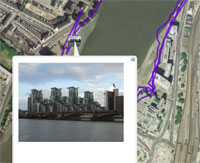
Viewing your photos in Google Earth
Using Picasa2, you can save your photos in a Google Earth file and share your entire journey with your friends and family.
- Just load your photos into Picasa2 (File -> Add folder to Picasa)
- Select the photos you have just added
- Click Tools -> GeoTag -> Export to Google Earth
- Select a location, where you want to save your file.
Gallery2 / Blakepics
Finally, all of these photos can tie into Gallery2 (which is what I’ll be doing) using the existing Google Maps Module, or watch this space on Tadek’s blog, for a really promising looking module to view locations on single images.
Useful Resources
I came across a number of other useful little applications out there, which while weren’t directly useful to me – might be very helpful to you, so here they are 🙂
- WMMX Location Stamper – Stamp your photos with GPS information. Totally Free.
- Google Earth – The best way to view your photos afterwards 😉
- Grazer – Another GPS stamping application
- GPS Visualizer – A great online tool to sort our your GPX files, and much more.
- Photo Studio – John Hawkins’ explanation of geotagging with Photo Studio.
- GPS Babel – Converts your GPS track files between loads of different formats (though wouldn’t play nicely with the track stick – let me know if you have more luck!)
- Robo Geo – nice tagging tool, but it’s a pay-for software and doesn’t really do the job any better than the rest of them.